Trails Illustrated Map: Pacific Crest Trail: Klamath Mountains: Siskiyou Summit To Castle Crags
SKU
pg78806
As low as $14.95
Free Shipping*
Available to ship now
Free Store Pick-Up
At any of our Tucson locations
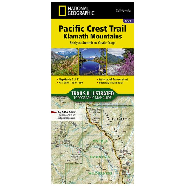
The Pacific Crest Trail (PCT) covered in the Klamath Mountains Topographic Map Guide in this part of northern California travels through the Klamath Mountains and parallels the southern end of the Cascade Range. The distinctive regions of the Cascade Range, Coast Ranges, and Central Valley converge at the Klamath Mountains, creating an environment with unparalleled diversity. The PCT reaches the Siskiyou Mountains near Ashland, Oregon, then travels through the Marble Mountains and Russian wilderness areas . As the PCT travels further south it passes through the Scott Mountains before arriving at the picturesque spires and domes of Castle Crags, a granite intrusion exposed by millions of years of erosion.
The PCT spans 2,650 miles from the Canadian border, through Washington, Oregon, and California to the southern terminus at the Mexican border. The famous trail crosses some of the most wild and scenic landscapes of the western U.S., including six national parks, 25 national forests, 48 wilderness areas, the volcanic Cascade Range of the Pacific Northwest, the snowcapped Sierra Nevada, and the Mojave and Sonoran deserts.
Each PCT Topographic Map Guide includes detailed topographic maps at a scale of almost 1 inch = 1 mile. Each page is centered on the PCT and overlaps with the adjacent pages so there is little chance of getting lost. Along the bottom of each page is a trail profile that shows the distance between camping areas, trailheads, and other points of interest. The map and trail profile provide a step by step visual guide to hiking the trail, mile by rugged mile. The Topographic Map Guide is built for all levels of hiking enthusiasts, from the day tripper to the multi month 'thru-hiker'. The front pages of the printed Topographic Map Guide include resupply locations, health and safety information, and much more.
More convenient and easier to use than folded maps, but just as compact and lightweight, National Geographic’s Topographic Map Guide booklets are printed on "Backcountry Tough" waterproof, tear-resistant paper with stainless steel staples. A full UTM grid is printed on the map to aid with GPS navigation.
Specifications
| Product Number | TI00001006 |
| Dimensions | Folded: 4.25 x 9.38 in |
| Scale | 1:75,000 |
| Pages | 48 |
Brand
National Geographic Maps